
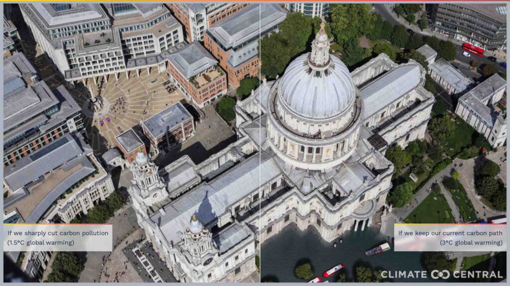
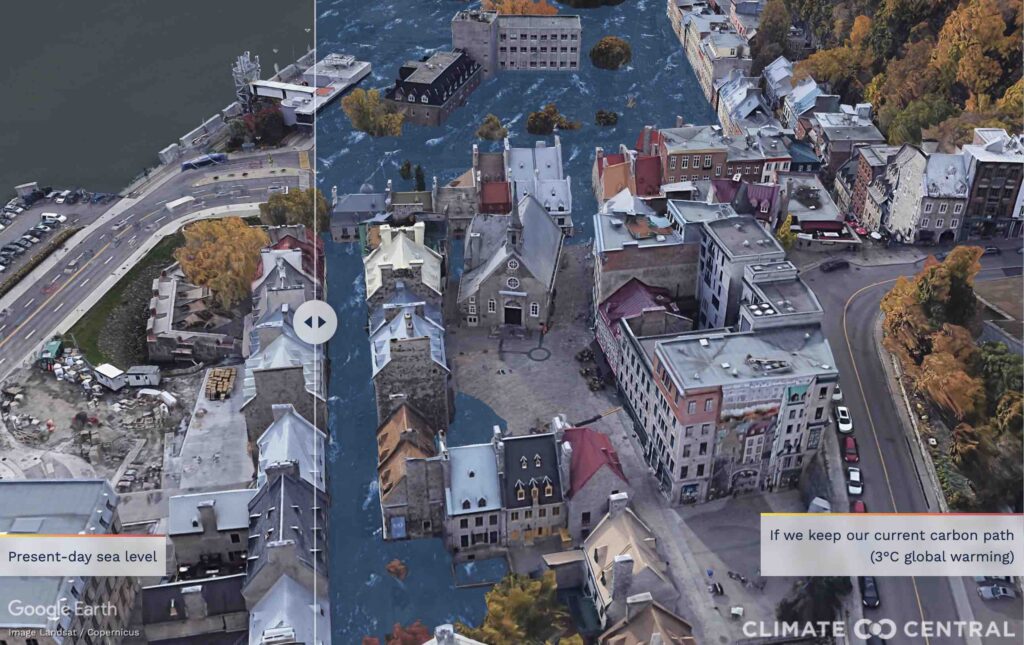
Climate change often reaches the public through graphs, targets, and diplomatic language. Then a single image erases that distance. Climate Central’s sea level reconstructions work with that exact force. They place familiar coastlines inside a harsher future. Havana appears to be overtaken by Caribbean water. Washington, London, Seville, Hong Kong, Dubai, Rio de Janeiro, Cape Town, Barcelona, and San Francisco follow close behind. The shock comes from recognition, not fantasy. Streets still look usable in the frame. Buildings still appear solid and valuable. Yet the water line climbs high enough to challenge every claim of permanence.
Those pictures carry weight because scientific modeling supports them. Climate Central’s broader work tracks land exposed to future annual coastal flooding and higher seas. The World Meteorological Organization says sea level rise has accelerated in recent decades. Earth.gov explains that human-driven warming expands seawater and melts land ice. By 2050, the danger will not arrive on one dramatic day. It will arrive through repeated floods, damaged infrastructure, saltwater intrusion, rising insurance costs, and brutal decisions about protection. That is the real meaning of future climate predictions. They describe a world already moving toward the shoreline’s next conflict.
What Climate Central’s Images Really Show
The first responsibility in writing about these images is precision. Climate Central did not simply declare that every city shown will disappear by 2050. Its maps identify land projected to fall below the elevation of an average annual coastal flood. That distinction changes the conversation significantly. A city can suffer deep loss long before permanent submergence arrives. Roads can flood more often during ordinary tides. Drainage systems can fail during routine storms. Groundwater can turn saltier and harder to use. Insurance can become pricier, narrower, or simply unavailable. Property values can weaken in places that already lack public investment. The political strain can then spread across the whole city. Schools, clinics, ports, and rail links can also become harder to protect.
Climate Central’s 2019 Flooded Future report put hard numbers behind that risk. It found that land now home to 300 million people could sit below annual coastal flood levels by 2050. Earlier estimates were far lower because older elevation data carried major errors. Climate Central’s CoastalDEM model corrected much of that problem. The result was a far more severe picture of global exposure. Climate Central says today’s decisions “influence how high sea levels rise for hundreds of years.” That sentence gives the imagery its moral force. The pictures are not decorative warnings built for social media circulation. They are visual arguments about decisions being made right now. When viewers see Havana, London, or Cape Town wrapped by higher water, they are seeing geography placed beside policy. They are also seeing the limits of denial.
Climate Central’s coastal tool makes another caution clear. It does not include every local defense, levee, seawall, or drainage barrier that governments may build. Yet that caveat should never be mistaken for safety. Defenses cost money, demand maintenance, and rarely protect all neighborhoods equally. The most profitable districts often receive the fastest protection. Poorer districts often receive delays, partial works, or official silence. That inequality defines many climate outcomes more than engineering talent does. By 2050, some cities may still look intact from the air. Daily life on the ground could look very different. Commuters could face flooded access roads several times each month. Water and sewer lines could suffer repeated corrosion and overload.
Families could discover that a home survives physically while its value collapses financially. Small businesses could reopen after one flood, then fail after the fourth. Municipal budgets could bend under repair costs that never truly stop. The images matter because they make those slower losses visible. They show climate change entering the street, the mortgage, and the municipal budget. Transit schedules, emergency services, and school routines can all become less dependable. Residents then absorb the stress through time, money, and repeated disruption. A city can remain standing and still enter decline. Investors also watch these signals long before official retreat enters public language. Once the capital grows cautious, recovery becomes slower, costlier, and politically harder. That is how climate change turns a coastline into a prolonged economic test.
Why the Sea Keeps Rising
Sea level rise begins with heat, and the ocean absorbs most of it. Earth.gov says around 90% of the excess heat trapped by greenhouse gases enters the ocean. Warmer water expands and occupies more space along coastlines. At the same time, glaciers and ice sheets lose mass on land. That meltwater then flows into the sea. Earth.gov says about 33% of the present sea level rise comes from ocean warming. It attributes roughly 66% to melting land ice. Those figures help explain why climate change and rising seas move together so closely. One process enlarges the ocean itself. The other adds more water to it. Both are driven by global warming caused by human activity. There is no hidden mechanism waiting to reverse them quickly.
The World Meteorological Organization now says key climate indicators have again reached record levels. In its 2024 climate report, WMO used unusually stark language. It said sea level rise is “irreversible for hundreds of years.” That phrase deserves close attention from every coastal government. It does not mean every future loss is fixed. It means the physical system now carries long momentum. The ocean responds slowly, but it responds relentlessly. Heat stored today keeps working long after a single year passes. Recent measurements show that the rise is not only continuing. It is also accelerating over time. Earth.gov explains that the global sea level rose about 10 centimeters between 1902 and 1992. It then rose about another 10 centimeters between 1993 and 2023.
WMO’s 2024 climate report adds a sharper figure. The long-term rate of rise has more than doubled across the satellite era. It increased from 2.1 millimeters per year during 1993 through 2002 to 4.7 millimeters during 2015 through 2024. NASA also reported that the 2024 sea level rose faster than expected because ocean warming expanded the water more than forecast. A slower increase in 2025 did not change the broader curve. Year-to-year shifts can move the line slightly. The line still climbs over time. That matters for future climate predictions because 2050 is now close enough for infrastructure planning. Ports, airports, wastewater systems, coastal roads, and power networks are built for decades, not seasons. A city cannot wait until floodwater reaches its center.
By then, adaptation becomes reactive and much more expensive. The science, therefore, carries two clocks at once. One belongs to the ocean and ice sheets. The other belongs to politics and finance. Physics sets the direction, while policy still influences the eventual height. Every delayed decision adds pressure to an already rising baseline. Local outcomes can also worsen because land itself may sink or erode. Storm surges then ride on a higher starting point. Even small increases in average sea level can therefore produce much larger increases in flood damage. That is why coastal planning can no longer treat 2050 as a distant abstraction. For engineers, lenders, and mayors, it now sits inside an ordinary professional horizon. The calendar has moved much closer to the water.
Cities Flood Before They Drown
Cities do not wait for permanent inundation before they begin to change. They start changing when flooding becomes frequent enough to disrupt ordinary life. NOAA says high tide flooding is already occurring more often across the United States. Its 2026 guidance gives a stark estimate for 2050. High tide flooding is likely to occur between “45 and 85 days per year,” depending on location. That figure matters because it describes routine disruption, not a rare catastrophe. Streets can close during sunny weather. Parking lots can flood without a named storm. Drain outlets can back up when tides stay high. Shops can lose foot traffic because access becomes unreliable. Emergency vehicles can lose precious minutes on affected routes. Schools can lose attendance when travel becomes harder and less predictable. These are not images of cinematic collapse.
They are symptoms of a city becoming harder to use. Earth.gov also notes that higher baseline seas make flooding during high tides and storms more frequent and widespread. Higher seas allow future storm impacts to reach farther inland. A surge that once caused inconvenience can now cause heavy damage. As the baseline rises, thresholds fall. Floods that once seemed exceptional begin to feel ordinary on the calendar. People then adapt privately before governments adapt publicly. They buy pumps, raise floors, move cars, and alter routines. Those individual adjustments can keep households going for a while, but they do not solve the civic problem. The civic problem is cumulative strain. Roads, sewer lines, storm drains, rail corridors, substations, and clinics all depend on reliability.
Once water interferes often enough, reliability begins to erode. Repair crews return to the same trouble spots again and again. Insurance claims also become more common. Maintenance budgets grow faster than tax revenue. Public trust also weakens when disruption becomes repetitive. A city can manage one flood with urgency. Managing dozens each year is something else entirely. Families start asking whether a neighborhood still justifies the stress. Employers start asking whether transport links still justify the address. Lenders start asking whether long-term value still supports the loan. That is how a working city begins to enter retreat before any official retreat is declared. The IPCC’s assessment on cities by the sea warns that coastal risks are high across the globe. Those risks grow especially severe under higher sea level rise projections.
Without adaptation, exposure to a 100-year coastal flood rises sharply even with modest sea level increases. The crucial point is practical, not poetic. Cities begin failing before permanent inundation arrives. By the time permanent submergence dominates the headlines, years of quieter damage may already have changed settlement patterns. They may also have changed insurance markets, lending decisions, and neighborhood investment. Businesses can survive one season of flooding and still fail after repeated interruptions. Hospitals can stay open while ambulance routes become less dependable. Residents may remain in place while daily confidence steadily deteriorates. That slow degradation often arrives well before formal evacuation or buyout plans. When that point arrives, a city still functions, yet it no longer functions with confidence. Investors usually notice that change early.
Why So Many Major Cities Are Exposed
The list of cities in Climate Central’s imagery looks global because the danger is global. Havana, Washington, London, Seville, Hong Kong, Dubai, Antwerp, Adelaide, and Melbourne appear in one sweep. Bordeaux, Copenhagen, Rio de Janeiro, Cape Town, Dublin, Quebec, Stockholm, Guangzhou, and Taipei follow close behind. Barcelona, Palm Beach, and San Francisco complete the warning. These places sit inside different political systems and very different coastlines. Yet they share one hard reality. Valuable urban life often concentrates close to the sea. Ports, river mouths, flat deltas, sheltered bays, tourist waterfronts, and historic harbors long attracted power and investment. That history now creates a dangerous inheritance. The same geography that once made these cities prosperous now leaves them exposed.
UNESCO says many coastal heritage cities are “increasingly at risk” from sea level rise. Rising seas do not only threaten property values. They threaten archives, waterfront districts, old neighborhoods, museums, rail terminals, and working ports that hold civic memory together. They also threaten the public spaces where urban identity becomes visible. Additionally, they threaten trade corridors that many national economies still depend upon. When water enters those places often enough, a city loses more than land. It also loses continuity between generations, institutions, and daily routines. The social map of loss is just as important as the physical map. Wealthier districts can buy time with barriers, pumps, raised entrances, private insurance, and legal influence. Poorer districts often face longer delays and weaker protection.
That imbalance already shapes many climate outcomes across the world. Cape Town offers a useful example because sea level risk there intersects with a long history of inequality. It also intersects with uneven infrastructure and strong coastal dependence. The City of Cape Town says climate change will lead to sea level rise. It also notes that coastal erosion is already happening. Its 2050 long-term plan says the city and its partners have invested in climate responses. Those include climate-resilient infrastructure and protection of the natural environment. Those efforts are serious, but they also reveal the scale of the challenge. Protection requires constant funding, technical capacity, and political continuity. It also requires choices about which assets get defended first. London, Rio, Hong Kong, Barcelona, and San Francisco will face the same argument in different forms.
Leaders must decide which shoreline deserves the wall and which road deserves elevation. They must also decide which district absorbs the remaining risk. Climate change turns those decisions into tests of justice as much as engineering. Water will not treat every resident equally, and neither will many governments. The same tension will appear inside tourism, housing, and transport policy. It will also appear inside heritage protection and emergency planning. Every coastal capital will discover that adaptation is also an argument about belonging. In many places, the hardest fights may concern access, not abandonment. Residents will ask who stays mobile, insurable, and politically visible. Those questions will define urban climate change as clearly as any flood map. Some neighborhoods will be heard before others are.
The Political Test Between Now and 2050
The hardest truth in climate change is that 2050 is neither fully avoidable nor fully fixed. Some sea level rise is already locked in because oceans and ice sheets respond slowly. Yet the scale of future damage still depends on choices made now. UNEP’s Emissions Gap Report 2025 says current national policies still point toward much higher warming than the Paris goals. That means future climate predictions remain closely tied to present political behavior. The world has not exhausted its options. It has simply narrowed them severely. Every additional fraction of warming raises long-term coastal risk and makes adaptation costlier. The same decade that produced the most striking sea level imagery also became the decade of harder decisions. Governments now need to cut emissions much faster.
Cities must upgrade drainage, transport, and power systems. Coastal authorities must restore wetlands, protect dunes, restrict unsafe building, and plan retreat where defense no longer makes sense. Those steps require money, public trust, and administrative stamina. They also require far more honesty. No city can defend every meter of coastline indefinitely. No government can promise universal protection at any cost. Once leaders admit that reality, climate policy becomes more serious and more politically dangerous. It starts choosing between timelines, assets, and constituencies. It also starts revealing who carries the cost of the delay. That is where adaptation now collides with finance. UNEP’s Adaptation Gap Report 2024 uses especially direct language. It says “progress in adaptation financing is not fast enough” to close the gap between needs and flows.
Read More: New Study Predicts Grim Future for the Arctic by 2100 if Climate Change Persists
That sentence captures the central problem facing many coastal cities. Engineers often know what should be built. Planners often know which neighborhoods face the greatest exposure. Emergency managers often know which roads, substations, and hospitals sit in the danger zone. Yet plans stall when funding arrives late, arrives unevenly, or arrives with weak political backing. By 2050, the most important divide may not separate cities that understood the threat from those that missed it. It may separate cities that financed action from those that postponed it. The world still has room to avoid more serious damage, especially if emissions fall faster and adaptation becomes more credible. Climate Central’s imagery should therefore be read with urgency, not fatalism.
The purpose of the warning is clear. If governments continue drifting, more coastlines will enter chronic flood exposure, and more urban systems will fail under repeated stress. If governments act with speed and discipline, some damage can still be limited. Some communities can also still buy meaningful time. The world inherited in 2050 will not be chosen by water alone. It will also be chosen by policy, money, and political courage. Delay is often described as caution, but coastal systems do not interpret it that way. Water simply keeps rising while budgets, permits, and election cycles move more slowly. The cost of hesitation then compounds across infrastructure and household risk. By the time consensus finally arrives, cheaper options may already have vanished. That is the timetable embedded in climate change.
To see what other cities could look like if sea levels keep rising, check out Climate Central’s Picturing Our Future
A.I. Disclaimer: This article was created with AI assistance and edited by a human for accuracy and clarity.
Read More: The Moment That Changed a Climate Skeptic—And the Glacier Collapse That Followed